Category: Rural Exploration
At The Bottom
In 2014 on a Urbexcentral excursion in the hills- Gunner (as per usual), saw this tower as a challenge rather than an obstacle and couldn’t be talked out of free climbing it. We waited in trepidation at the bottom, as he proceeded to knock the bastard off.
Pastoral Arts
Elvis was the tender age of 19 when he recorded “That’s Alright Mama” in “a new, distinctive style” on the Sun label. Many of the arrivals at this commune founded in 1973 were of a similar age, seeking to live in a new, distinctive style under the sun. A painter’s easel stands overlooking the hillside on which the communal meeting house was built, and the nearby house still contains once-cherished paintings and art books.
All You Need To Know
From Ten To Two
130 years after its construction, and 40 since its abandonment, the dripping continues, and the clay is still incredibly boggy.
Thanks to The Forsaken Explorer NZ for directing me when I got a little lost on the hunt: https://www.youtube.com/channel/UCsDB2AmI-Lr4EhHOgZxA7Ag
Butt of a Joke
Congratulations to The Forsaken Explorer NZ, Urban Kiwiana and KEWM for tracking down Poro-A-Tarau last year, and special thanks to The Forsaken Explorer NZ who promptly and kindly directed me when I had lost my way. Links to their videos of the tunnel are below.
https://www.youtube.com/watch?v=VQh4_nK0r7s
https://www.youtube.com/watch?v=66KJ7nEdyeA&t=3s
https://www.youtube.com/watch?v=96a8bm7oifI&t=34s
https://www.youtube.com/watch?v=R9lv1ucPRlQ
https://www.youtube.com/watch?v=SS6uFvBpcgQ&t=540s
Out of Bounds
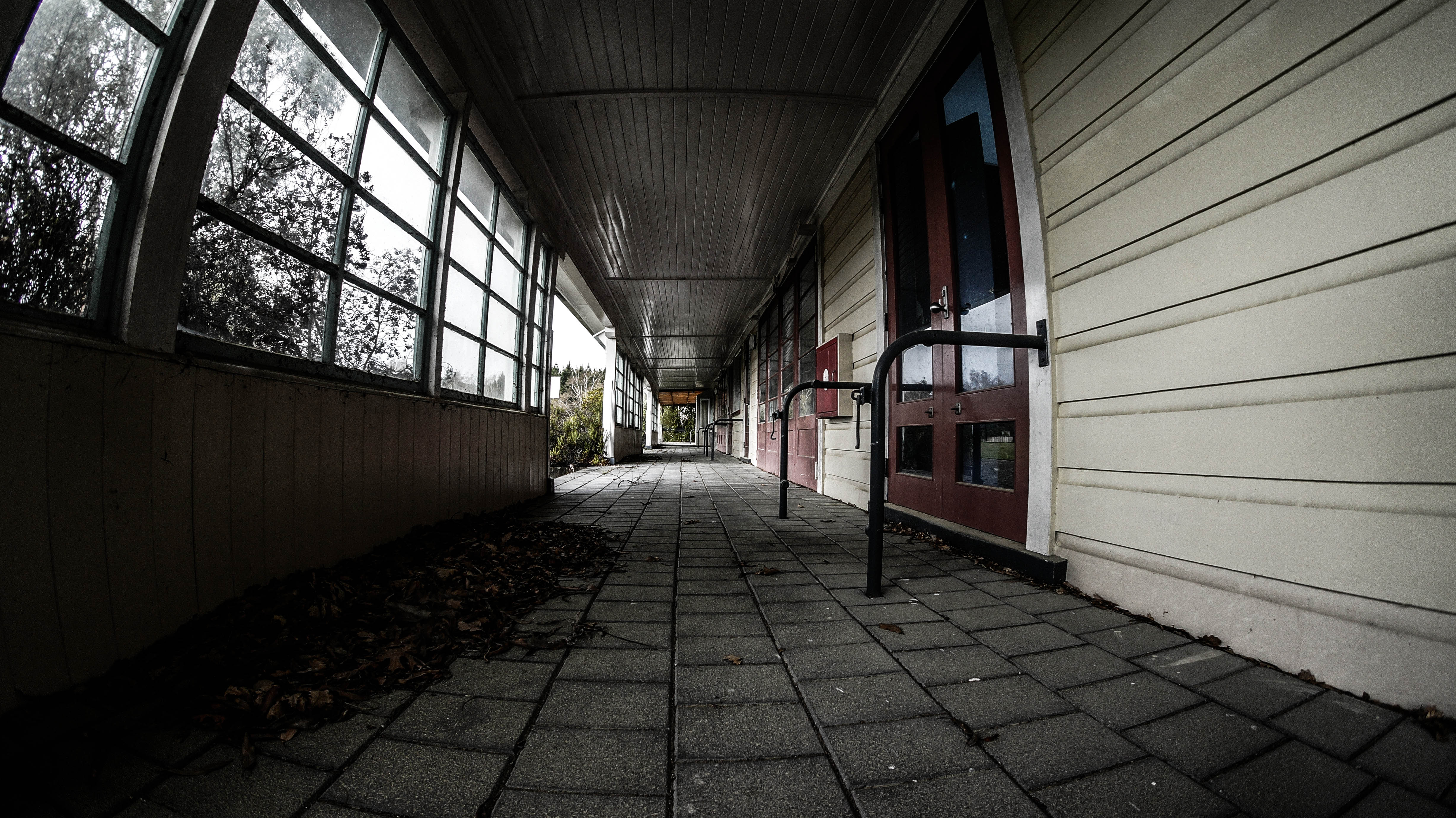
Part One: “Out Of Bounds” [0:00] Prisons have existed on this site for nearly a century. During the Second World War, conscientious objectors were detained here. In the 1950s the site housed a prison farm which was further developed in the late 1970s. The scale of the site — thousands of hectares of commercial and native forests, farms, wetlands and a river — meant that a perimeter fence was impractical, deemed only ever suitable to house up to 600 inmates at a minimum to medium security level. From 1998 the prison began to suffer repetitional damage, with a seizure of almost $1 million worth of cannabis plants growing on site, a buckets-for-toilets scandal, two inmate drownings involving Māori cultural training, canoes and parachutes, and a guard convicted of supplying cannabis to a prisoner in return for a bribe. The closure of this unit – one of four we visited as the autumn sun was falling fast – was announced in 2012, and the land and its buildings have now been returned to their original owners. No signs of the commencement of demolition were then evident, and — gratifyingly — no signs of vandalism. A 360-degree panoramic mural painted around the walls of the dining hall conveys a sense of geographical placement among the majestic landscapes beyond the perimeter of confinement, tantalisingly out of reach.
Part Two: “Man With Short Arms” [6:30] Perhaps some kind of neuroscience was at play in this choice of images — SpongeBob SquarePants meets the lost city of Atlantis — for a mural painted along the back corridor of the isolation cells of this unit. Presumably intended to calm disruptive prisoners, and engage painterly ones, further intriguing murals adorn the cold cell walls: a man pruning the limb of a tree so anatomically uniform that he might just as likely be an electrician working on wires strung from a lamp post; a Māori wahine wearing a pounamu and a kākahu feather cloak — barefoot on a pedestal — turning her face to the light; a man surveying his upcoming twisting traverse into a landscape crowned by an active volcano, with only a briefcase to sustain him; and the man with short arms — seemingly ill-equipped to utilise the key to freedom that lies beside his truncated frame with its enormous feet.
Part Three: “Traces of Time” [11:49] From the window of #55, an informed eye studies the moody skies above the central courtyard. Glenn’s 1972 Christmas present — The World Encyclopedia of the Film — languishes in #11, its front cover torn off but not yet discarded. #18 plays host to a brown-crayoned face, mouth agape as if inviting the throwing of ping pong balls at a fairground amusement. Nearby a grey-bearded pig farmer and an athletic woman carrying groceries seem to be missing an opportunity to converse at the fence line. Monied wanderlust is palpable in #16, where a shrine to cars, boats and exotic getaways gleams under fluorescent light. Outside Sunday church services advertise the promise of personal transformation via belief in a higher power, while inside #37 another route to growth is being chosen. The number of 5 — denoting maximum difficulty — is written into every column associated with expressing affection towards anyone from an intimate partner to a shop assistant.
Part Four: “But They Can Die” [16:30] The pigs of George Orwell’s Animal Farm proclaimed, “All animals are equal, but some animals are more equal than others”. Pigs are similarly the object of resentment in under-the-mattress graffiti in Cell #26 of this former prison. The poem begins burnt into the wood: Pigs CAN’T FLY and continues in blue pen: BUT THEY CAN DIE NEXT FINE DAY BLOW A Pig away IF YOU KILL A Pig a day it WILL Keep the doctor away Nowhere more clearly did we find articulated the smouldering frustration of incarceration, channeled into the kind of blind hatred that negates any opportunity for insight. Elsewhere was a mixture of light and shade. In the kitchen the relative gentleness of a rainbow framing the extractor fan was juxtaposed with murals depicting fearsome hyper-masculine muscularity. No such diverting decor was provided for prisoners in solitary confinement, who were required to surrender their tobacco products and were issued with fresh water, a chamber pot, one mattress, one pillow, one pillow slip, one sheet, and blankets or duvet “in accordance with climactic conditions”. How some of them obtained implements sharp and sturdy enough to partially chisel their gang names and insignia into the stone walls and into the paint of their cell bars and doors is anyone’s guess. Puzzling at what we had experienced, and all the more aware of our own freedom of movement and expression, we walked for ninety minutes back down the road through pine forests to where we’d parked our car.
Across Time
Hive Minds
According to records marked on a chalkboard inside, April 1993 appears to be when beekeeping operations ceased. A quarter of a century later, a falling pine tree has done its utmost to topple the workshop, and the whole commune sits decaying in the landscape, somewhat like a giant set of deserted beehives. The ‘hive mind’ of the commune has fragmented and dispersed. Or rather, it has shifted shape. A stream of ants is relentlessly appropriating the remnants of the 1993 honeycomb, hauling tiny piece by tiny piece back to its nest. Given enough years, the ants alone will demolish all that remains of this once-prosperous collaboration between humans and nature.
MX3030
Raw
Down River
Pentagonal Dreams
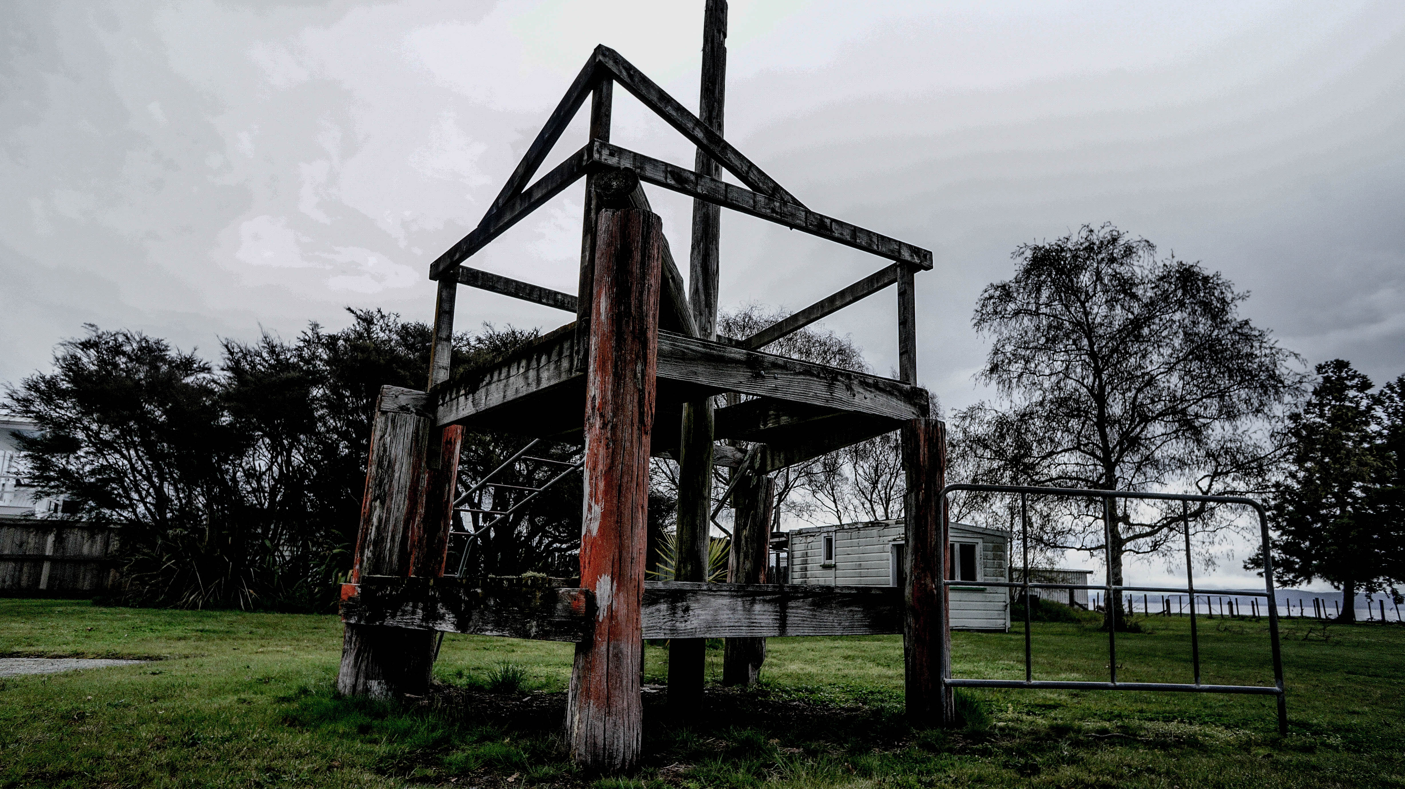
Ohu
Ohu is a Māori word meaning ‘communal work group’. Ohu communes were set up on unused Crown land, with their residents paying leases matching those of farmers grazing their livestock on government-owned land. Some saw the Ohu Scheme as a calculated initiative to remove radicals from urban settings, while its stated objectives were: to assist people in becoming self-sufficient from the land; to enhance people’s spiritual and social wellbeing; to reconnect people to the land; to give people a chance to develop alternative social models; to provide a communal environment as a potential antidote to the ills of modern society; the promotion of the virtues of a simpler life; to be a place of healing for participants as well as for society as a whole.
The area in which this ohu commune was situated had originally been gifted to servicemen returning after World War One. However, by the time of World War Two, the land was abandoned and the access track winding its way through steep terrain steadily returned to bush. It took the 1970’s ohu founders three months of hand cutting and digging to rehabilitate the track sufficiently to allow even horses to reach the ohu site. Over the course of its lifetime, up to five couples with children lived at any one time at the ohu, and undertook a range of initiatives to explore self-sufficiency, including gardening, bee keeping, dairying, manufacturing butter and soft cheese and hunting meat. Quirky DIY housing flourished in a climate of limited resources, salvaged materials, amateur architects and builders, and a relaxed attitude towards regulations. The central meeting house was an exceptional architectural achievement. Its circular form, pentagonal upper floor and feature windows, and domed timber ceiling constructed of triangles forming interlocking hexagons speaks to the utopian ideals of its community and era. It now cuts a lone, striking figure amidst a rewilded landscape.
By 2000, the same forces of isolation and endless hard manual labour that had prompted the returned servicemen’s families to walk away had again splintered a community, and the ohu dwellers departed, seemingly taking with them only what they could carry on their backs along the hour-long walk down to the river crossing to conventional civilisation. In recent years, former residents have expressed a desire to return to the ohu and transform it into an outdoor education centre. However, the Department of Conservation remains unconvinced at present that the group have the resources required to restore the buildings to safe habitability and to mitigate against the environmental impact of reoccupation. And so for now the remains of the ohu quietly stand as an inspiring – and perhaps also cautionary – tale about utopias and visionaries.
Trees Company
Driving rural back roads in the Waitomo region, we came across several well-worn former abodes. Interestingly to us, many a collapsing farmhouse had a companion tree somewhat alleviating its loneliness, presumably planted by its former occupants.
Keith Butler
Preoccupation
Know Your Biorhythms
Waterpark
Late last year we explored the abandoned waterpark “Ho Thuy Tien” near Hue, Vietnam. This place has been fairly well documented by UE and backpackers before, so to mix things up a bit we decided to predominately explore the park via bicycle- and we’re talking about the old school one speed bicycle variety with a basket on the handle bars.
It took 30-40 minutes in the heat & humidity to bike there from Hue city, courtesy of Google Maps. At the main gate we were surprisingly waved through by a guard. We were expecting a “fee” like all other locals and visitors alike. Perhaps he felt because we’d biked all the way out there we deserved the “free” entry- what ever the case it was good karma. Locals we spoke to later just could not believe we’d been given “free” entry.
Closed a decade ago- probably because of the high priced tickets and lack of attractions- the park has over the years become a hang out for local youth, urban explorers, backpackers, and on weekends (in this case) a bus load of students. Apart from getting the neck slit gesture after outstaying our welcome at some local lads bbq on top of the waterslide section- it was a safe and surreal experience- and then we had to bike all the way back to town…
Casino Rouge
Exploring the ruin of the French colonial era Bokor Casino Hotel in Cambodia recently. The Casino was fought over by the invading/liberating Vietnamese army and the murderous Khmer Rouge from 1979 onwards. Due to it’s strategic place and size on Bokor plateau it was invaluable to either side to gain an advantage over the other. In recent years it has been cleaned up and somewhat structurally improved- unfortunately removing most of its neglected charm, tragedy and history in the process.
Church : Time
Exploring the abandoned former French colonial era church on Bokor Mountain in Cambodia recently. In 1978 the Vietnamese invaded Cambodia, toppling the murderous Khmer Rouge in a matter of weeks. There was however a stalemate for a time on Bokor (and other locations) as the Vietnamese and the Khmer Rouge battled it out- fighting between the church and nearby casino. In recent years the church has had occasional use- it’s first in nearly four decades. “Nobody knows the trouble I’ve seen…”
West Coast ghost town
Once a thriving railway township, Rewanui was abandoned in 1985 when the railway branch was closed. The town was taken care of and preserved by its caretaker until in 1988 where a huge landslide following a flood destroyed most of the buildings and bridges that remained, tragically killing the sole occupant of the town.
After quite a long walk and a lot of searching through bush we found many remnants of the past still exist throughout the valley including old coal carts and mines.


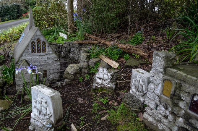
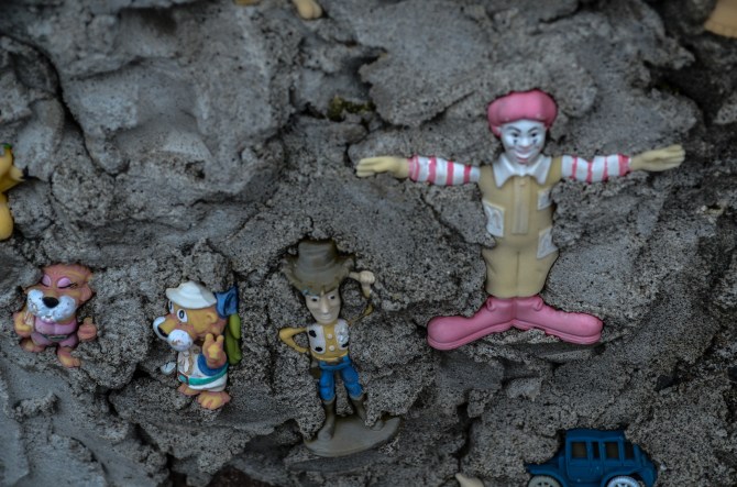
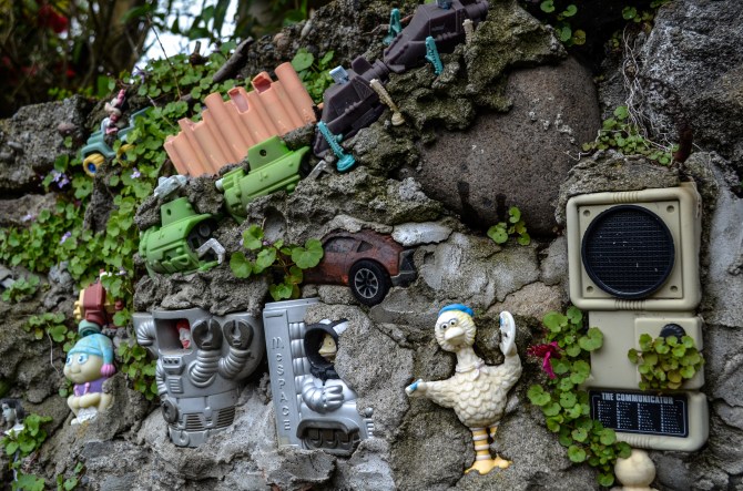
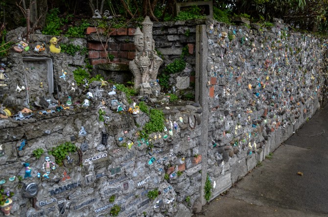
New Zealand’s forgotten miniature village
In a small rural town of North Island New Zealand lives this little forgotten wall and village.
Once a labour of love for the pastor of the church who has now passed on, this little village and its figurines continue to decay without repair or anyone to take care of them.


Nokor
Not your usual urbex video, but exploring ruins nonetheless. This is the strange fusion temple complex of Banteay Prey Nokor in Cambodia that we visited late last year. Situated in countryside near the town of Kompong Cham, the original 11th century Mahayana Buddhist shrine has been added onto over the centuries and incorporated into a bewildering and sprawling complex of wat’s and stupa’s. Apart from a security guard and a couple of monks we had the place to ourselves. More to come from Cambodia soon…
Kingdom’s gone!
This derelict and forgotten film set was never actually used for filming as the movie was mothballed after running out of money. The set still stands waiting for its film crew and producers to perhaps one day return.
Exploring this abandoned movie set in the middle of rural New Zealand countryside was quite the experience, as we wandered through the film set which was designed to look more like Jerusalem than New Zealand it felt like we were entering some kind of cartoon world. Everywhere we ventured was artificial and built by film set designers, from the walls and floors to the odd props and building materials that were left lying around and never used.
")
")
")
")
")
")
")
")
")
")
")
")
")
")
")
")
")
")
")
")
")
")
")
")
")
")
")
")
The Mansion
Built out of New Zealand native kauri wood in 1899 and the largest structure in New Zealand around in its time, this grand mansion is slated for demolition following extensive earthquake damage.
The mansion was built lavishly both inside and out for a Scottish immigrant Allan McLean, and its beauty is resounding even in its currently dilapidated state. McLean donated his mansion to women’s education upon his death, a worthy cause – we hope McLean’s can eventually be restored and not demolished.
Exploring one of Christchurch’s last grand mansions still standing brought emotions of amazement and sadness as we looked around its unique beauty and its so-far-decided future, demolition.
")
![o58ÇìÖ¿CÉúù¹ìì_ìì(çböä´±ª"¥²o£zUúÂNÐ.¢ÿÔ;?:æ.GGV»~È?¥,I/óÖ¢JWghO3@zqifå!O?¼¦¥M.çá3³5Rjz"¸íAnæeËÀGÁ®éu?úNx×ýÊÕq'a, g~ñ/ÖOUyÀ¸>©^Ú¼¿÷^÷þ!ÿÅûï?JpÐöÍ6Ý@Yý%éD²ªÒÏ*»H&±$²¤¯ªOZÀîAUÂÁî#I2"àq¦¡×Ò_ipaæ¸^pv§¬~ê^¹vAé°õ¾ÏÆÌÇ|Ç'þø¥ûF*ï´qaÝÛãà*±Ç?Q/i{ºdcÌk#JX£é·[càÉüC/åZÍEÃGãkù,|E:{$ÍÃN?2é©ý×Åuáַø¼x>çÿZÌÈíl´9bqýO7C?Ó7c'>;$£ ËÜZ»1kûÇvX-é $9©ôýWó¨w/_?Ê&6ìÙ_ùeÓ÷e"º»îQíãêÄã¥Å«k«S/øK¤_Ë-ýû·Wbå}>ÔíD#Ðf<ýÇÿG*ä¦7Áj1ÿÄ#®?*ó_lMËä¶ÙAñÈ°}ø¥ðò?´ÐÝ{°¹Z½*Ú9Vð<zr'¤8ÄŪd'f<¼3öKÔ×Ú|~¿gþÇCk¯ÃÿpFO§ùW^DB,Ä»t¿¶fèÿo+Üê3tÎ/u0HWö¼TàþÕý KØjÉ$QI·Ôe Ï´f®Éa@À,9 y#(UÏCµ*Èrîxô{#b¨JãÒvÊ("ºäùù79=3 SË}êK1»ÞÌ°Ú¸CãYݪMãmÕlH5»%Ú·NôhzNoEIÏüöó´Ï¢]I%³îw'v±È9(åö
oÕªÃÃɽëêJyÒà6ûä;åÌDo4ÔµÝÅahÁ3ÏÊ)oW¥Tk¹5â?jþJeìúéÝ¡í&g¨wöh×˲îVu#ÃxVxb»g¾DaÔÉö!器êcec°-ÿÑÇû#pPcï"L¤Q¢Ùz·±à:$ûF*3z(½R?øõÏý9?ùR¶Ó¥ôÊ|íãîüªfÙ¤ö¨ßZþö:ìG5IÆ¡~«Ñh¢ß¦2ÿGâ~t8éw~utôN}NAäÐGoµË=H´8.Öìð~Íâ|.×dy_¹ pFöÞQíoÁÿÊ¥|f9¨/üF/ÚÞZó%Áßyù4±·ÿÿz·_hÄÏí.Î>u?ïÀ×¢ùG2à»[n)%Âãqõ>Ï×¢ú=ò_iý¿«îÿÇõê]vþHôéþøk®dÑvås©Z!t¶oò¯;¿îu®÷IMÓ¿ô#?ijâ«%¯HF¥Þ¾bÂT£MÊA³~±£Ô/J-?&Ý·í¿i~S{1¦jºååýº´ÉÒRñó»ÕQrt$¢¨çðºü¯vCÏw,PèDC3¶ä>«üÌæUB¸ÝÀ¨K:ã 7º(Cû³CTcÿÒ¡Þüë]Å{}Iw!ôdep]ãF7â¹üÄËS,q!&#%pOº[C ÝR!é:ñü6°ü)Nè§u´Ï¿÷£Èüj©è³'L´,Ü´$|jk²/G,ÂçÔ½*<AÿÛ?åTb¡Åä §Ì7rÏï$ø<}¤É©ÄxÙpؤ~UÄÐÖÑlì
Æÿ'WV3¥ÏwrPxàÆ3Å][Ä×Ô©dO¸æ¨BúMì{ýfiCu!âFÉ÷ÑÆý¸¦välyWÄ÷dÏúcZ-k6Û¡c íIö;_uÆ[_¹´ÿ`MgR}ën^rGNþu²÷¶ÓøÕY4µ 4zñêIcð*ieÀcÉË3ê°xþ9ÿ:á:~ÉüèÝ»ÓÙ.Ó¨+¼c]£xÞÎÓ¬_;7¥£ÛÉË1PY¸'0¯Z Ãä¶_qS×mÿJ§ªÁ ÷£PÉÉle-6¶`¨Ä³HþÚ0ük©Ghzbu}:87ìGÝþµ<ñ¦6'hÎïãÿÄ=¿×fv#tù9ù$Çõ³Má#slw¢ß*fXÛË5ÛmÓ!䱸ôP«q2¨½QÉS!=ßý:ó³_O2ûïÏÿÔuBJøÝÿ?Ü5,ÞÇÏþ¬qaWÈÈDÆû^ÿ˾¬GûG®UÏît£:
´·_tÇôX±û¥
ý¤¾
r{PvyÁçÍucÆ9Æ9ëXÂ8ßI +}¹®(èDÖÍÉHç?W¦ ¿Eª¬ç×(ó"qÆÏðZÒ4íCå;:)qii§ÜÌÑÈ¡vQ þÕRN!6ÍóEüË7Ä2äÿÔ³|¤Ü[ê' yÞö
$[ÖL`tú¦¸«i+V°¶x1ûð:a;K0µÓ,ån¸6GáSDÝ% ÐÇón¯ð#üêO°YÿpG¸³Îºq{N|z¬y´u û¤Ê®É ËÈÃC:ÒïZ=õ·w¯ÞEç#Füq5ê:äÚí£±¹¶#ÔiXnõGSVðûTsxSAý^â&s#z¤¹'ú§åñ"ÜHÞ3]¯Õî}Ù|äµâ(ØyõÛé×â9ýêÿçý3¯MñgóýäkÍ >rËýç«d"¶O.[ÊÚãïç§J3ÖØMôrÝO5ù?ppOk¤&ÿX¶ïP×í¬a=èÉÚr|«vùÏñ:®zÊ£ÃÚi£Èð3yñ¸cÌ~x`ñF À>5Y½Ú¾¸àð8¥±4(Tüæf¹¹³Ò¡ûDFleÊÚXÊ@¸È>4Úl]ÑÿÕÕußãÇIHÈ#¶h·Oíñ®:.ù,½"}*9G"H£}¥Ò×{?{«Ûê$íw²àÊíN⹧ÙTÒFa¢|¢v®Ò(åô¦¸d/;¾Ö÷x×}¯£|þÿ(ú¿jîµKËX¡OîeY£-¹G#W¢U`DfmzÉfq¸~5^ÄïPOé¢7Åhvs9×-¶ö6>?Ñ&¸æ½Eãíì$¼Kx9ø §JÙÞt¾ÔhwrnÚ`øQ"E#dN=U5°zVßQl±o
Dgin EÌ$gee$8ueäÓÆ¥lK°TòìÓtY:aíIÿÛEÿ U½Gê%nDº~e½Çî"âá{2mQñª!ú¥ÏõyTz(×þLu"ìÑÉÇÛCú³+Eúkò4cÈOß]³IÑVl{OÙý&ESâ#&¦'Gòb7ò°½}_Ò® âí$þñK®3Q«¯aiòØ««Ë+x5fIYb®^G`9m˾H¿%·lìø]zr+éI©ÇlÝLOwhdéÇ*ßG6ÿ1äø)ï+´3 -àm<å]~I.¯ÈwFíh/µt´à@s'k,jNÆyÇ«EâHN»=¸Õcàõi [ÌæXÆÐßhuÙ¯4«A.»oltàRÆ;(ÉT1öþh¡fÁÔ7rr2Þ }µGÉ(ûOFÞ/ªqöV|rx«ml©ç§ÚÀfÉò/uc¦|ü¡jrÜÇ硬6³ª´Æàíäã¼ð«bÛ9¼DnQFNÅÆr /Ñ϶¸ÚÑÞ{×D«Æ|ékhnÂiúy÷ É 6ÏÿÖÅ¡¸Ö碶·X;#fã'ì®t3gù=~gmpW)n»ân ØÀæÛswmÙ}NâÐdÚFÇUAýlda¶ §aIûë®<fÇü$[;ÒÞcýÚÄò ÿ#+ApÉNÖïmäÕá0ÆÙPøÅrd~£¢G;#«élº_0X¦L&rrÞ°ÀØhà{fËHÒu¢Òo}ä=¼HÇ c$cßC½/v>HúªEq¤ åÑ=èìGÝSÊíØÞ«Ú[m.Ú+×ô~è¡#s8Ê£¼õ5Tì%T{òǤÌвJS;Km{³O:04DO{¦êzEØvÚǸpQÎsôzÖ¹>ÉþËöÂ}ÅqlJTqQJö½÷Ê2ÞÜÅ,JQbrO'<Ùdäа#4í¿hSZ½.ï%rnúf1îéVðrÜú
ÌôÁHÅe¯è7oüÜz¥£?Ø$º2¯K'ÕÛnÐÙÊ^ÜJ¢y9ÛÞÏ5ç(³¥3·â ìèIwQ>åWÀlO4¶7MÜ
,%ÈãëE4+?ÿ×·ìN¼àwÍojNí!øúÕÈÎìUL]ê7BVÝV.ßYª2ÍËEüßÖÒtÎÇêvö
üegv,ä/ N:{)#JIGúVÌ·GGfǨMÜÕècàæ%ßä?µ-¶Óª^^O/wÐ`·$%¥kF±o¨Ü(P1_èÊêñ¡ëNOEÇaü¨ùºFÈ)îXÛÍ.}e(Ù÷×4h¢?´ú¤ú~×P¨wIâFijýº·&âF½Lá¹úÈß÷ç)ƶ5¦[n»A¦¬ÓrxBðsë ÜqöÔÒa!gí6MÌIÕÍŪ[èÑYÜÚʽä9dÛÈggñdz¦´"ö<ڴɧP5¹?MB´ÙxOS(4ìcú¾µ8Ñ.å³g¶¹îee2PÃ}¨äñ~cu`XëÔÙ'a§évñ7¤,WÊKI c·ö@"¸gâ&Þ´tyQ³Î¶QÂ׺ËÆPDÀØã$:èÈDÑ&ÕÉ OÜfgmÅKç¡Ç["ø%VÌ·äc E%ÀÉ1ø§>x§VMÐÓ©À¦BKòw$¯0ãruð¨Ir"fÂ}ßMA>²íTzØÉéD[8e¼ÏNh c¬wÏsãÉÊÉ/öÊê+UÓÄ[-cS¹Bàõ-À4ÄmXÍïjL¯í4| È<ü)z6µCo®@ð-ã2sËgÛ* rø
·Ê9éV§gÿѺv î!kçÖ(®O§ydø".u](https://i0.wp.com/urbexcentral.com/wp-content/uploads/2015/12/mclarens-mansion-19.jpg?w=254&h=168&ssl=1 "Mclarens Mansion (19)")
o58ÇìÖ¿CÉúù¹ìì_ìì(çböä´±ª”¥²o£zUúÂNÐ.¢ÿÔ;?:æ.GGV»~È?¥,I/óÖ¢JWghO3@zqifå!O?¼¦¥M.çá3³5Rjz”¸íAnæeËÀGÁ®éu?úNx×ýÊÕq’a, g~ñ/ÖOUyÀ¸>©^Ú¼¿÷^÷þ!ÿÅûï?JpÐöÍ6Ý@Yý%éD²ªÒÏ*»H&±$²¤¯ªOZÀîAUÂÁî#I2″àq¦¡×Ò_ipaæ¸^pv§¬~ê^¹vAé°õ¾ÏÆÌÇ|Ç’þø¥ûF*ï´qaÝÛãà*±Ç?Q/i{
ºdcÌk#JX£é·[càÉüC/åZÍEÃGãkù,|E:{$ÍÃN?2é©ý×Åuáַø¼x>çÿZÌÈíl´9bqýO7C?Ó7c’>;$£ ËÜZ»1kûÇvX-é $9©ôýWó¨w/_?Ê&6ìÙ_ùeÓ÷e”º»îQíãêÄã¥Å«k«S/øK¤_Ë-ýû·Wbå}>ÔíD#Ðf<ýÇÿG*ä¦7Áj1ÿÄ#®?*ó_lMËä¶ÙAñÈ°}ø¥ðò?´ÐÝ{°¹Z½*Ú9Vð<zr'¤8ÄŪd'f<¼3öKÔ×Ú|~¿gþÇCk¯ÃÿpFO§ùW^DB,Ä»t¿¶fèÿo+Üê3tÎ/u0HWö¼TàþÕý KØjÉ$QI·Ôe Ï´f®Éa@À,9 y#(UÏCµ*Èrîxô{#b¨JãÒvÊ("ºäùù79=3 SË}êK1»ÞÌ°Ú¸CãYݪMãmÕlH5»%Ú·NôhzNoEIÏüöó´Ï¢]I%³îw’v±È9(åö oÕªÃÃɽëêJyÒà6ûä;åÌDo4ÔµÝÅahÁ3ÏÊ)oW¥Tk¹5â?jþJeìúéÝ¡í&g¨wöh×˲îVu#ÃxVxb»g¾DaÔÉö!器êcec°-ÿÑÇû#pPcï”L¤Q¢Ùz·±à:$ûF*3z(½R?øõÏý9?ùR¶Ó¥ôÊ|íãîüªfÙ¤ö¨ßZþö:ìG5IÆ¡~«Ñh¢ß¦2ÿGâ~t8éw~utôN}NAäÐGoµË=H´8.Öìð~Íâ|.×dy_¹ pFöÞQíoÁÿÊ¥|f9¨/üF/ÚÞZó%Áßyù4±·ÿÿz·_hÄÏí.Î>u?ïÀ×¢ùG2à»[n)%Âãqõ>Ï×¢ú=ò_iý¿«îÿÇõê]vþHôéþøk®dÑvås©Z!t¶oò¯;¿îu®÷IMÓ¿ô#?ijâ«%¯HF¥Þ¾bÂT£MÊA³~±£Ô/J-?&Ý·í¿i~S{1¦jºååýº´ÉÒRñó»ÕQrt$¢¨çðºü¯vCÏw,PèDC3¶ä>«üÌæUB¸ÝÀ¨K:ã 7º(Cû³CTcÿÒ¡Þüë]Å{}Iw!ôdep]ãF7â¹üÄËS,q!&#%pOº[C ÝR!é:ñü6°ü)Nè§u´Ï¿÷£Èüj©è³’L´,Ü´$|jk²/G,ÂçÔ½*<AÿÛ?åTb¡Åä §Ì7rÏï$ø<}¤É©ÄxÙpؤ~UÄÐÖÑlì Æÿ'WV3¥ÏwrPxàÆ3Å][Ä×Ô©dO¸æ¨BúMì{ýfiCu!âFÉ÷ÑÆý¸¦välyWÄ÷dÏúcZ-k6Û¡c íIö;_uÆ[_¹´ÿ`MgR}ën^rGNþu²÷¶ÓøÕY4µ 4zñêIcð*ieÀcÉË3ê°xþ9ÿ:á:~ÉüèÝ»ÓÙ.Ó¨+¼c]£xÞÎÓ¬_;7¥£ÛÉË1PY¸’0¯Z Ãä¶_qS×mÿJ§ªÁ ÷£PÉÉle-6¶`¨Ä³HþÚ0ük©Ghzbu}:87ìGÝþµ<ñ¦6'hÎïãÿÄ=¿×fv#tù9ù$Çõ³Má#slw¢ß*fXÛË5ÛmÓ!䱸ôP«q2¨½QÉS!=ßý:ó³_O2ûïÏÿÔuBJøÝÿ?Ü5,ÞÇÏþ¬qaWÈÈDÆû^ÿ˾¬GûG®UÏît£: ´·_tÇôX±û¥ ý¤¾ r{PvyÁçÍucÆ9Æ9ëXÂ8ßI +}¹®(èDÖÍÉHç?W¦ ¿Eª¬ç×(ó"qÆÏðZÒ4íCå;:)qii§ÜÌÑÈ¡vQ þÕRN!6ÍóEüË7Ä2äÿÔ³|¤Ü[ê’ yÞö $[ÖL`tú¦¸«i+V°¶x1ûð:a;K0µÓ,ån¸6GáSDÝ% ÐÇón¯ð#üêO°YÿpG¸³Îºq{N|z¬y´u û¤Ê®É ËÈÃC:ÒïZ=õ·w¯ÞEç#Füq5ê:äÚí£±¹¶#ÔiXnõGSVðûTsxSAý^â&s#z¤¹’ú§åñ”ÜHÞ3]¯Õî}Ù|äµâ(ØyõÛé×â9ýêÿçý3¯MñgóýäkÍ >rËýç«d”¶O.[ÊÚãïç§J3ÖØMôrÝO5ù?ppOk¤&ÿX¶ïP×í¬a=èÉÚr|«vùÏñ:®zÊ£ÃÚi£Èð3yñ¸cÌ~x`ñF À>5Y½Ú¾¸àð8¥±4(Tüæf¹¹³Ò¡ûDFleÊÚXÊ@¸È>4Úl]ÑÿÕÕußãÇIHÈ#¶h·Oíñ®:.ù,½”}*9G”H£}¥Ò×{?{«Ûê$íw²àÊíN⹧ÙTÒFa¢|¢v®Ò(åô¦¸d/;¾Ö÷x×}¯£|þÿ(ú¿jîµKËX¡OîeY£-¹G#W¢U`DfmzÉfq¸~5^ÄïPOé¢7Åhvs9×-¶ö6>?Ñ&¸æ½Eãíì$¼Kx9ø §JÙÞt¾ÔhwrnÚ`øQ”E#dN=U5°zVßQl±o Dgin EÌ$gee$8ueäÓÆ¥lK°TòìÓtY:aíIÿÛEÿ U½Gê%nDº~e½Çî”âá{2mQñª!ú¥ÏõyTz(×þLu”ìÑÉÇÛCú³+Eúkò4cÈOß]³IÑVl{OÙý&ESâ#&¦’Gòb7ò°½}_Ò® âí$þñK®3Q«¯aiòØ««Ë+x5fIYb®^G`9m˾H¿%·lìø]zr+éI©ÇlÝLOwhdéÇ*ßG6ÿ1äø)ï+´3 -àm<å]~I.¯ÈwFíh/µt´à@s'k,jNÆyÇ«EâHN»=¸Õcàõi [ÌæXÆÐßhuÙ¯4«A.»oltàRÆ;(ÉT1öþh¡fÁÔ7rr2Þ }µGÉ(ûOFÞ/ªqöV|rx«ml©ç§ÚÀfÉò/uc¦|ü¡jrÜÇ硬6³ª´Æàíäã¼ð«bÛ9¼DnQFNÅÆr /Ñ϶¸ÚÑÞ{×D«Æ|ékhnÂiúy÷ É 6ÏÿÖÅ¡¸Ö碶·X;#fã'ì®t3gù=~gmpW)n»ân ØÀæÛswmÙ}NâÐdÚFÇUAýlda¶ §aIûë®<fÇü$[;ÒÞcýÚÄò ÿ#+ApÉNÖïmäÕá0ÆÙPøÅrd~£¢G;#«élº_0X¦L&rrÞ°ÀØhà{fËHÒu¢Òo}ä=¼HÇ c$cßC½/v>HúªEq¤ åÑ=èìGÝSÊíØÞ«Ú[m.Ú+×ô~è¡#s8Ê£¼õ5Tì%T{òǤÌвJS;Km{³O:04DO{¦êzEØvÚǸpQÎsôzÖ¹>ÉþËöÂ}ÅqlJTqQJö½÷Ê2ÞÜÅ,JQbrO'<Ùdäа#4í¿hSZ½.ï%rnúf1îéVðrÜú ÌôÁHÅe¯è7oüÜz¥£?Ø$º2¯K'ÕÛnÐÙÊ^ÜJ¢y9ÛÞÏ5ç(³¥3·â ìèIwQ>åWÀlO4¶7MÜ ,%ÈãëE4+?ÿ×·ìN¼àwÍojNí!øúÕÈÎìUL]ê7BVÝV.ßYª2ÍËEüßÖÒtÎÇêvö üegv,ä/ N:{)#JIGúVÌ·GGfǨMÜÕècàæ%ßä?µ-¶Óª^^O/wÐ`·$%¥kF±o¨Ü(P1_èÊêñ¡ëNOEÇaü¨ùºFÈ)îXÛÍ.}e(Ù÷×4h¢?´ú¤ú~×P¨wIâFijýº·&âF½Lá¹úÈß÷ç)ƶ5¦[n»A¦¬ÓrxBðsë ÜqöÔÒa!gí6MÌIÕÍŪ[èÑYÜÚʽä9dÛÈggñdz¦´”ö<ڴɧP5¹?MB´ÙxOS(4ìcú¾µ8Ñ.å³g¶¹îee2PÃ}¨äñ~cu`XëÔÙ’a§évñ7¤,WÊKI c·ö@”¸gâ&Þ´tyQ³Î¶QÂ׺ËÆPDÀØã$:èÈDÑ&ÕÉ OÜfgmÅKç¡Ç[“ø%VÌ·äc E%ÀÉ1ø§>x§VMÐÓ©À¦BKòw$¯0ãruð¨Ir”fÂ}ßMA>²íTzØÉéD[8e¼ÏNh c¬wÏsãÉÊÉ/öÊê+UÓÄ[-cS¹Bàõ-À4ÄmXÍïjL¯í4| È<ü)z6µCo®@ð-ã2sËgÛ* rø ·Ê9éV§gÿѺv î!kçÖ(®O§ydø".u
")
")
")
")
")
")
")
")
")
")
")
")
")
")
")
")
")
")
The Farm
Inside an abandoned former catholic girls school/farm/’rehabilitation unit’ we visited in mid 2013. Founded by a French sisterhood in 1953 -“the girls who came into the care of the sisters often had problems that could not be resolved in their normal environment and needed the loving care of others to restore their sense of self-worth.” The first residents stayed at the ’13’-room Manor built by its previous owner; and over the years the Catholic order embarked on a building program that included a 25-girl dormitory, two-story working/training block, visitor accommodation and sports facility. The last building was an expanded convent for the growing number of sisters at the facility. At it’s peak there were apparently up to 50 nuns in the house, and at least 70 girls. The farm/school/borstal/convent finally closed down in the early 1980’s.


Chiller
A video from a couple of years ago- wandering around the creepy ruins of an abandoned cool-stores facility in Taranaki. Happy Halloween folks 😉
Inhospitable
Filmed in late 2011- this was the final days of the old Hawera Hospital (1925-2012). Demolition was already well underway on the South Taranaki Hospital, with at least half the complex already gone. A compact digital camera was rigged onto the hot-shoe of a DSLR to capture on video the state the place and what was being photographed- plenty of shaky camera footage ensued. Abandoned in 2002, the hospital’s state of decline over the next decade was dramatic and completely unnecessary. It wasn’t a pretty explore- a bleak and hazardous environment, the complete opposite of what a hospital is supposed to be about- inhospitable.
House on the Hill
Rural legend says this house was transported to its spectacular hilltop location sometime in the 1980’s. Allegedly the farmer who owned the property, had intended to renovate the house and make it the family home. Apparently though soon after the building was in place, the couple separated and the man was left to bring up the children on his own. Then, because he couldn’t afford to spend any more time and money on the house, it duly deteriorated and is still standing like a folly decades later. Check out our videos here and here.


WAIKUNE
After 30 years of decay this abandoned prison camp is barely recognisable as a prison anymore, this was a quick, fun early morning explore of a prison that was closed due to 1000 prisoners being released in New Zealand under the Criminal Justice Act in 1985.

“Waikune”

Cell blocks

Prison chapel

Prison chapel

Decayed floor in the prison chapel

Reception

Last remnant

Decor

Cell light

Cell

Prison dinner

Prison outhouse corridor

Tunnels

“Way of a man”
The Lost Resort
Anyone visiting Rarotonga for more than a few days, will probably have heard of (or seen) the doomed and abandoned Sheraton resort on the south coast. For a tiny country (pop. 14,600) which earns half of its income from tourism, completing the project is seen as vital.
The history of the project dates back to 1987 when the Cook Islands Government signed a deal with an Italian bank, after being unable to attract the required foreign investment. The Government acted as guarantors for the NZ$52 million loan and agreed to an Italian company’s bid to build Rarotonga’s first luxury 5-star 200-suite hotel and golf course. Sheraton signed up to manage the property and work began on its construction in 1990.
However within a few years, the lion’s share of $52 million disappeared down a black hole carved out by the mafia and other crooks- the project was 80% complete when the insurance firm cut off funding to the builders. Since then, Rarotongans have seen a steady flow of foreign receivers, consultants, con men, lawyers, bankers and developers trying to figure out what to do with the site. The country’s finances were crippled as the government’s liability ballooned to $122 million, and taxpayers are still saddled with the interest bill. The issue of who owns the hotel has been stuck in the courts for years.
Many locals think the project was doomed from the beginning, after a curse was thrown on the site in 1911- after More Uriatua was shot dead by William John Wigmore, following a bitter argument over ownership of the land. At the project’s official launch, Metua More’s grandson, More Rua turned up dressed as a high priest in warlike regalia, intoning the resurrection of his grandmother’s curse. He ended by slamming his spear into a rock onto which a plaque had just been unveiled by the Prime Minister, marking the beginning of the Sheraton project. When the rock split to ground level, the locals saw it as a sign that the resort was still cursed and doomed. It still lies abandoned and derelict today, with no new grand plans of completing The Lost Resort.


The Sentinel
This tower that once supported a railway bridge, now looks more like a prop from a Peter Jackson movie. A prop nonetheless, that Gunner was obliged to conquer…


Smash You Bro
This car wreckers yard was the set of the New Zealand cult classic film Smash Palace released in 1981. The junkyard offers a rare opportunity to see cars from multiple eras and in various states of decay – some are even in the process of being reclaimed by nature by means of plants growing inside them.


Car Graveyard


Ruapehu Railways
Standing at the feet of Mt Ruapehu are the remains of several railway viaducts in various stages of decay. Modernisation of the railway network and the move towards concrete bridges in place of the historic steel viaducts has meant that these symbols of industrialisation are no longer in use. One of the viaducts has been turned into a tourist attraction with the option of walking across it – on this viaduct I took the path less travelled and popped down for a look at the hidden service platform beneath its deck.


These steel pins held the wires taut.


Looking up at a viaduct

The viaducts are surrounded by wildlife and forests

This was the most decayed of the 3 viaducts

A disused rail tunnel looking out

A disused rail tunnel looking in

The new concrete viaduct with the old steel one in the background.

The steel rivets holding the viaduct together

The view of the viaduct from the platform beneath

The old wooden service platform beneath one of the disused viaducts

This was found under one of the viaducts
Cooler
Exploring the labyrinthian maze of a former cool store complex…
Trolleying
One of Wellington’s defining features is our fleet of trolley buses, we found a couple of older models rusting in a paddock and decided on an inspection. The old signs hark back to simpler times.


Ford
Fording a stream in a rather unconventional manner, because here at Urbex Central we feel you don’t always need to take Urban Exploration seriously 🙂
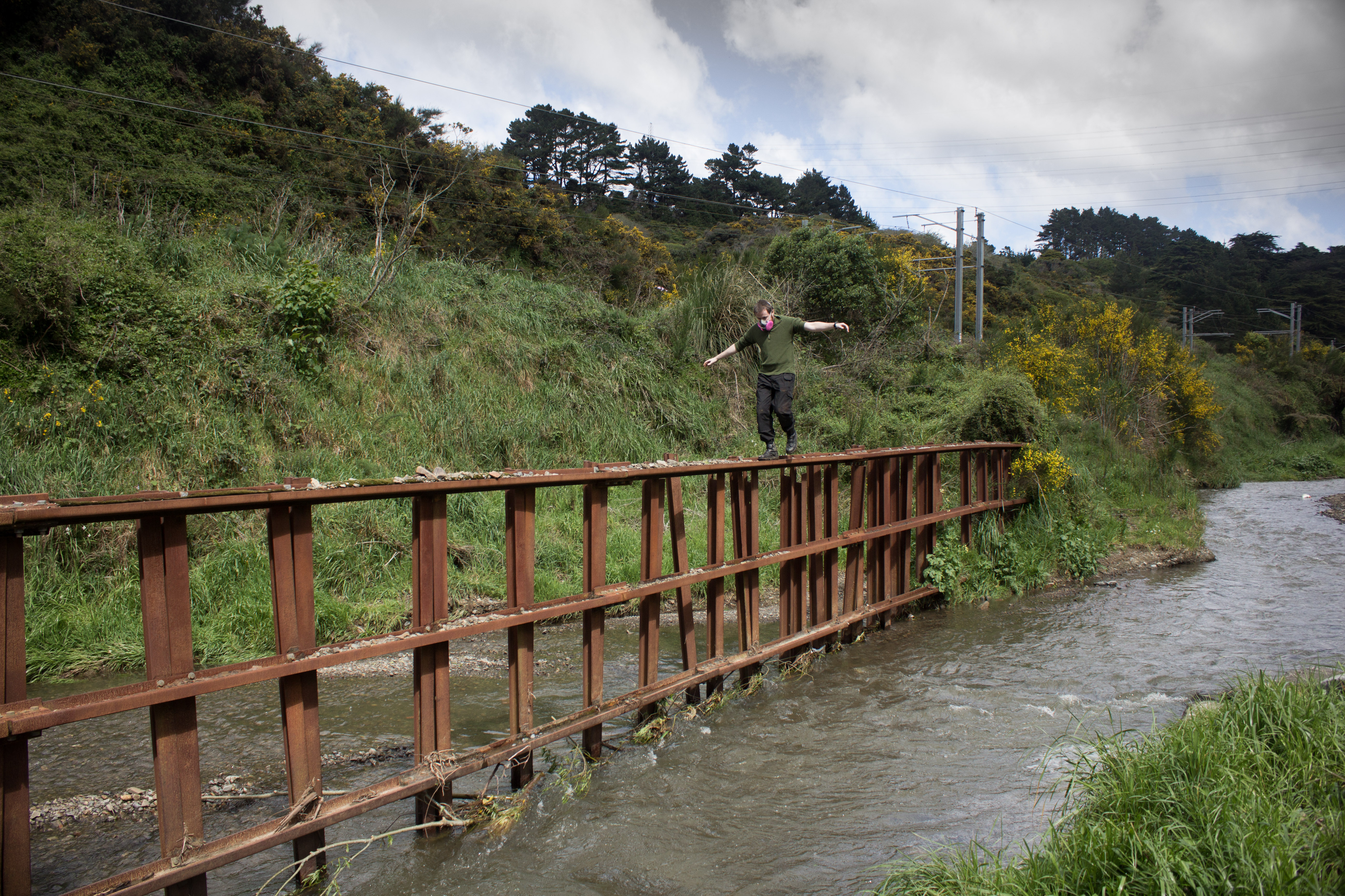


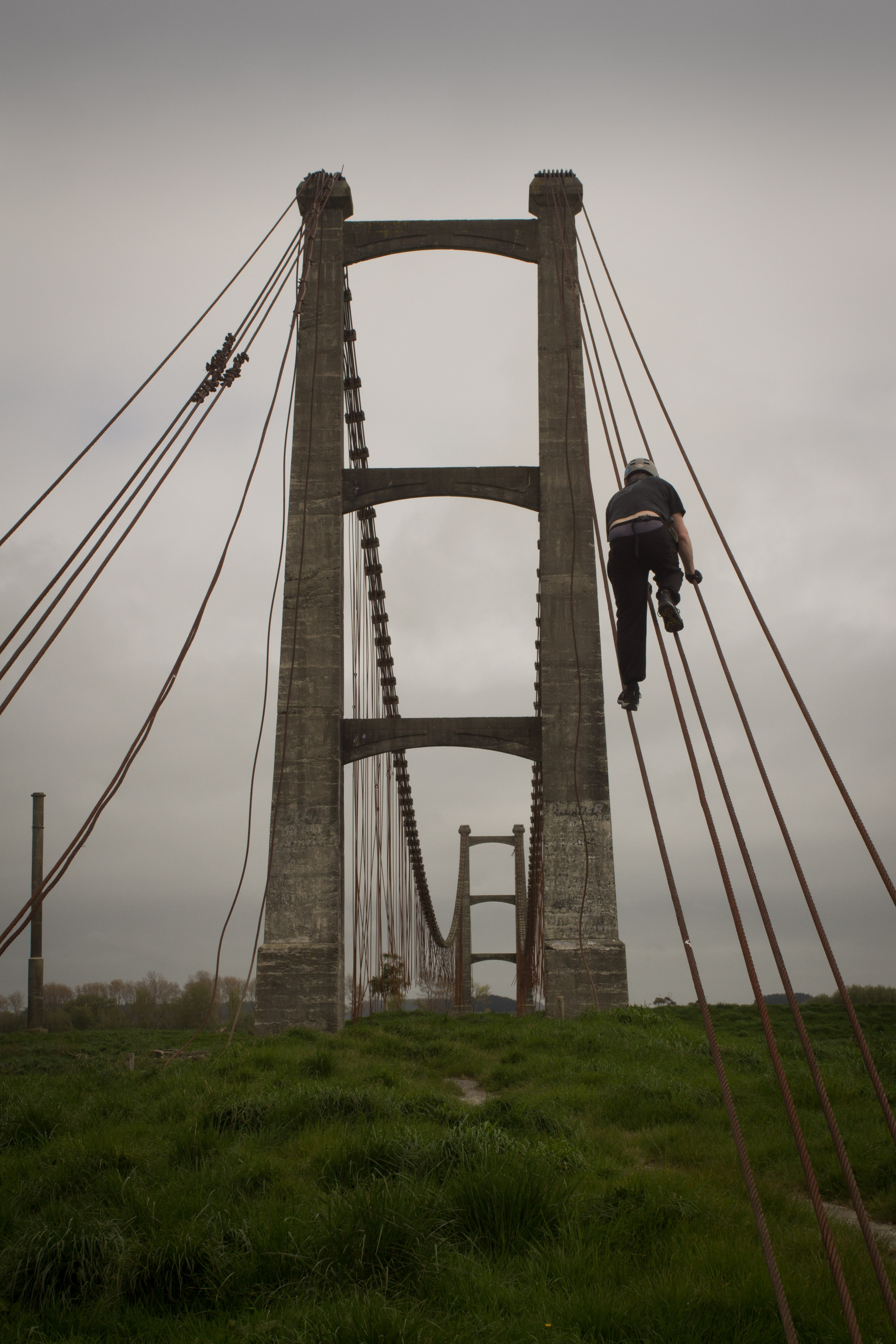
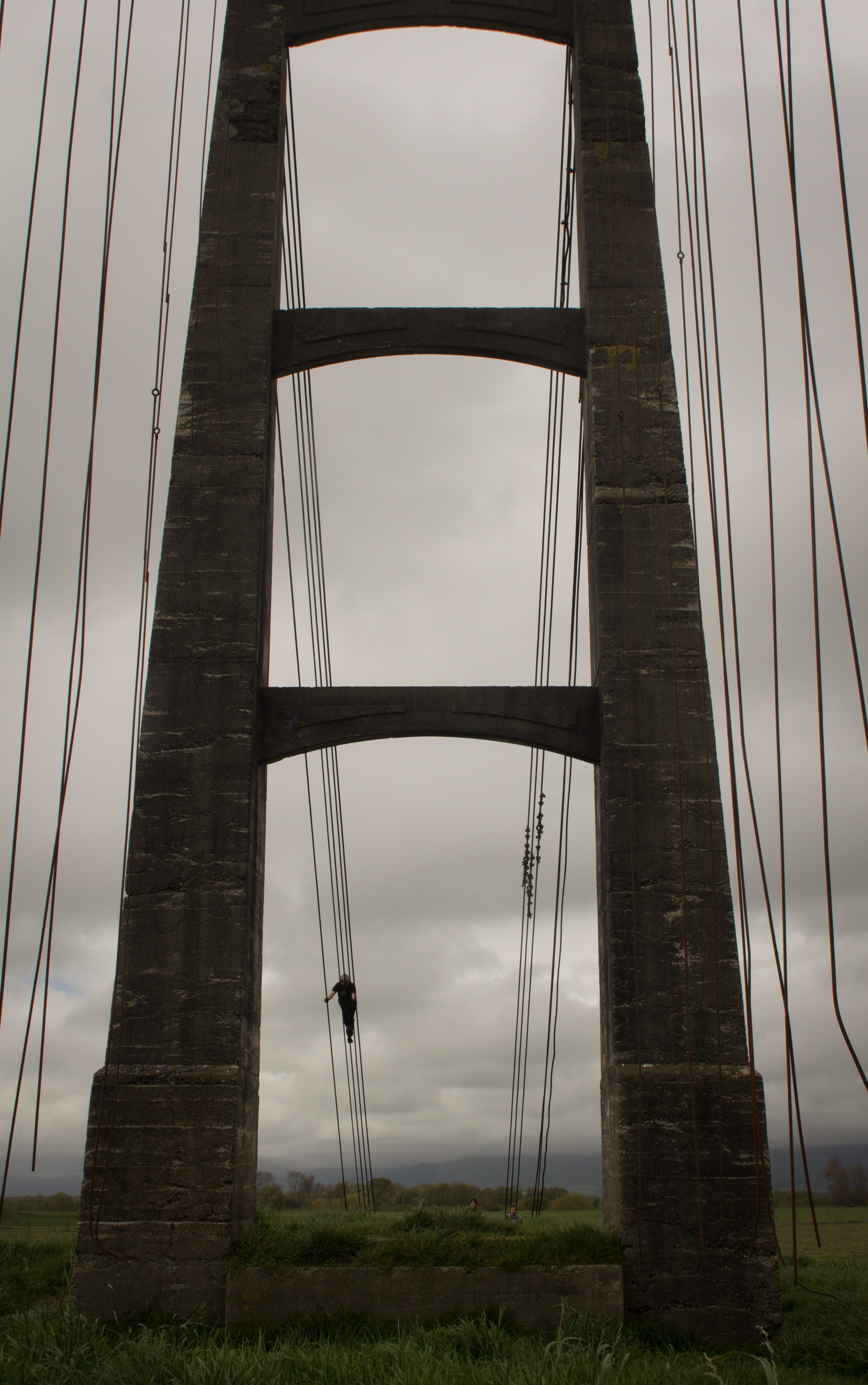
Man on Wire
Gunner gets in some tight rope walking practise up the cables of an abandoned suspension bridge. This particular bridge was a crucial factor to the success of this region in the early to mid 19th century. Check out Gunner’s video of the event here…


Water Wall
This defunct reservoir is no longer used to supply Wellington’s northern suburbs with water, despite that the weir remains full. The sunny day made for a good opportunity to experiment with some infra-red photography and high-speed video.


Rural Education
An old Primary school near Taupo my friend used to attend, now left to ruin after a decline in numbers.


Hilltop Sanatorium
This imposing building on the hill overlooking a small country town has had several uses in it’s lifetime.
It was initially constructed as a hospital for veterans returning home from the great war, before being re-purposed as a sanatorium (tuberculosis hospital).
After 60 years and over 7000 patients, and with the number of cases of TB in decline in New Zealand the hospital became a safe haven for the handicapped and for people suffering from head injuries.
The hospital has gone through another metamorphosis in the new millennium and is now used as part of a larger vineyard complex, we popped by for an inspection on our travels through the North Island.

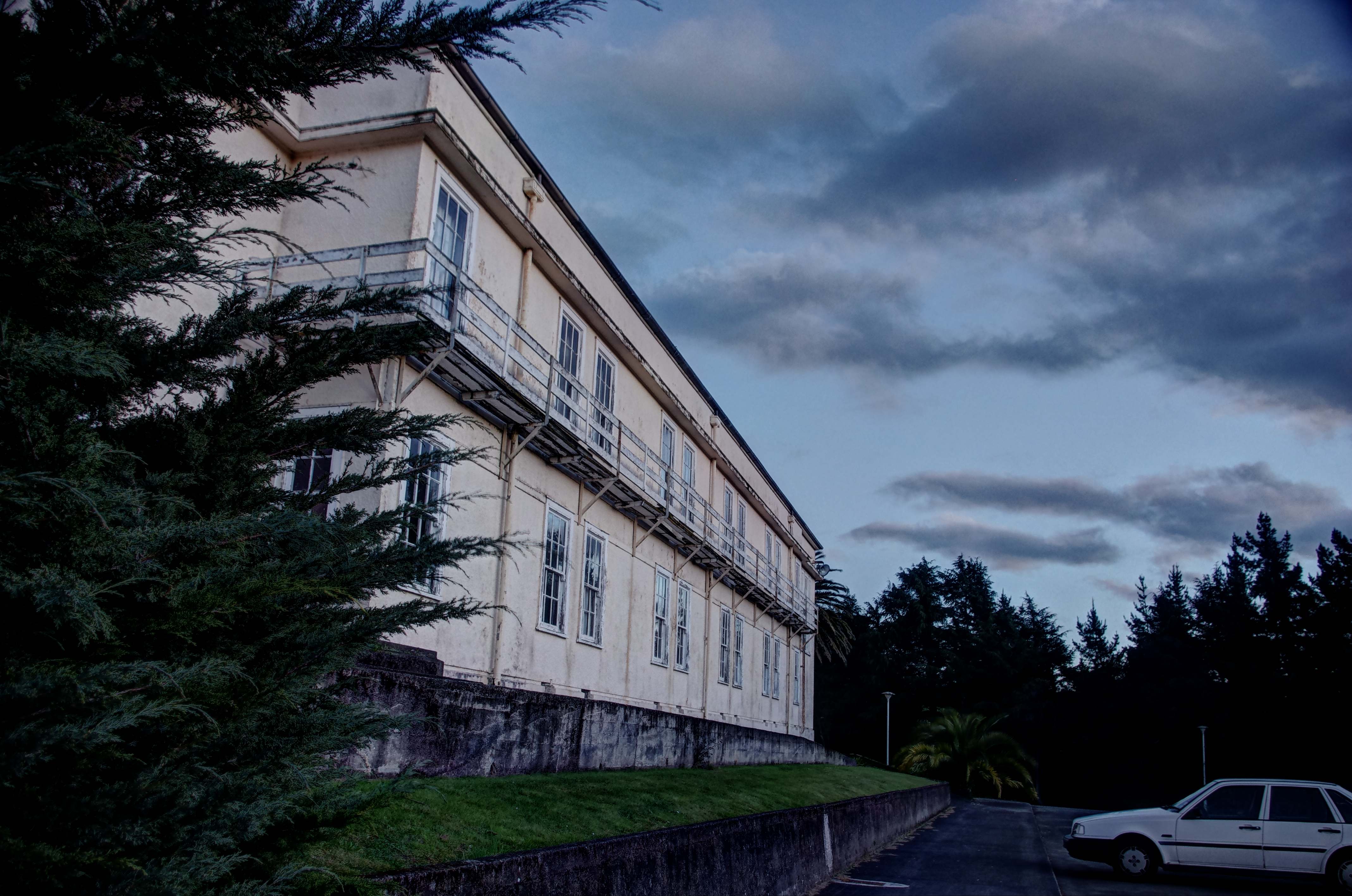

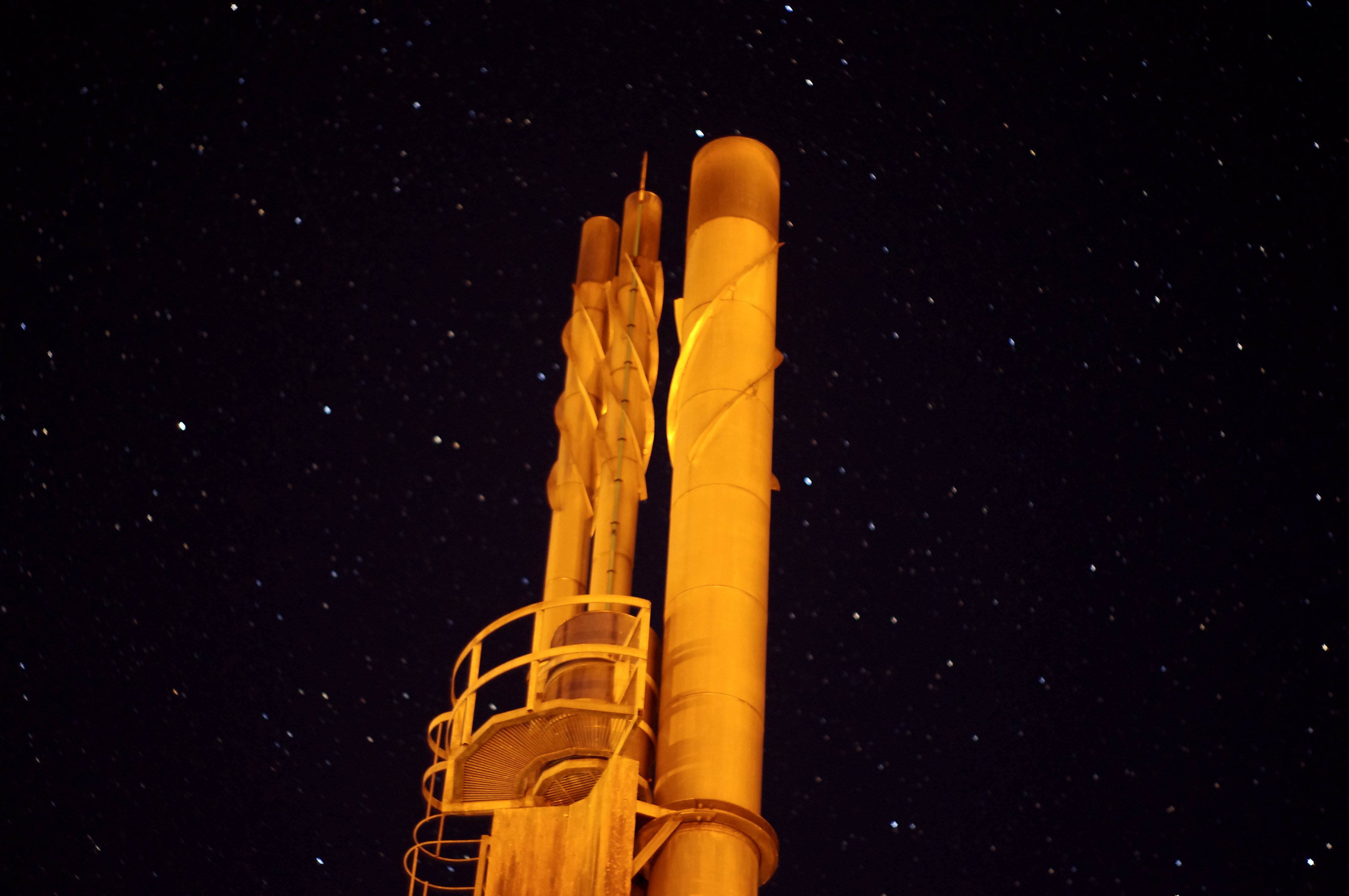
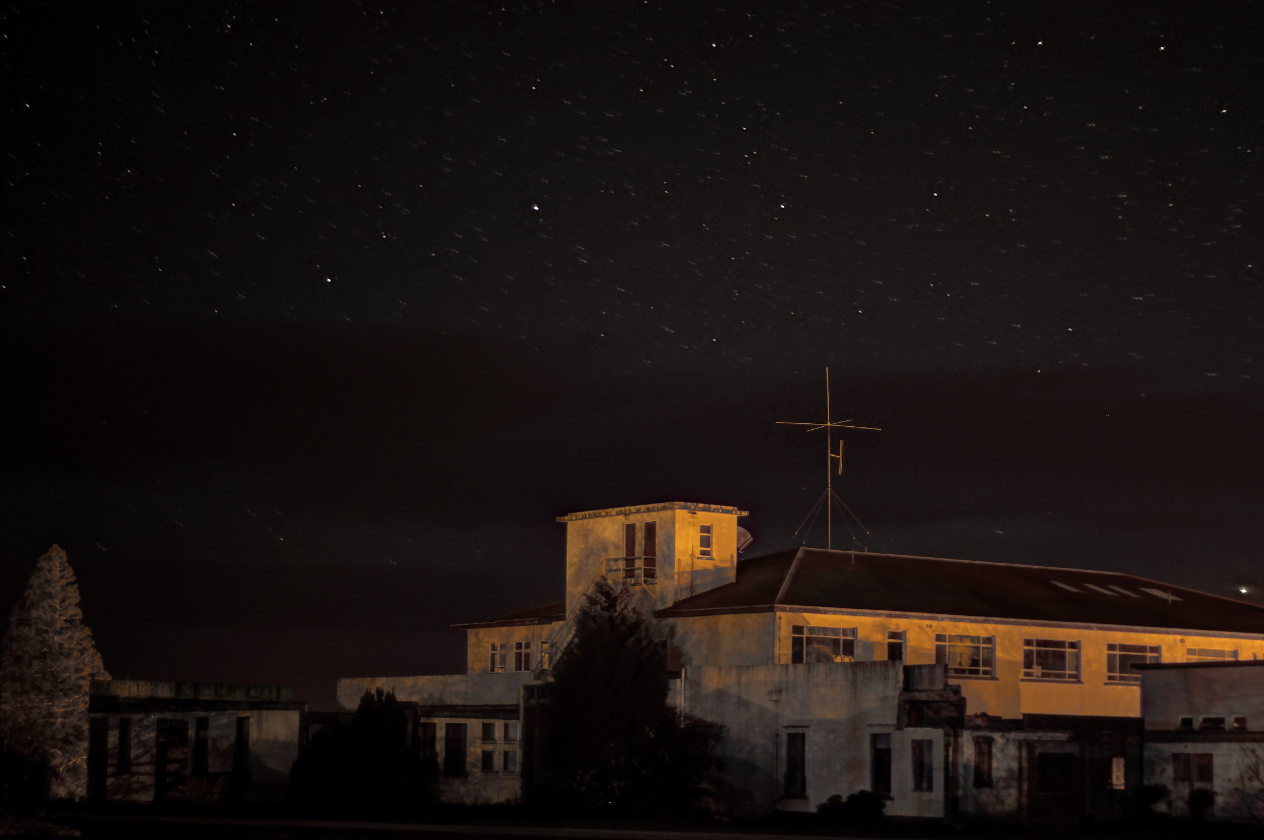
Night Riding
Driving through the Manawatu at night can be boring, but not when you have abandoned buildings and stars to take photos of!
Featured in this post are a strange concrete shed on a paddock, a quarry, and the hospital featured in this post (in a new light):
Stay tuned for more posts from this trip.


gymguano
Okay- so what else do you call a video exploring an abandoned school gymnasium full of pigeon poop…? 🙂
Freestyle
Sometimes we don’t even have to search for a new location- we just stumble on them. This abandoned rural school and pool is a good example. We came across it accidentally while taking some time out from exploring a nearby complex. Someone’s got to brush up on their freestyle strokes though 🙂
Beaufort
The Crusader fortress of Beaufort Castle- constructed in the 12th century- has been the focus for countless battles and the home of many occupiers over the centuries.

Beaufort (French for “beautiful fortress”) sits atop a 300 meter cliff which declines steeply to the Litani River. Its commanding location, with views over of much of southern Lebanon and northern Israel, is still of strategic value today.

In fact, Beaufort is one of the few cases where a medieval fortress has also proven to be of strategic military value, in the age of modern warfare.

In late 2005 the place was in ruins- but there was no mistake who held the high ground here.

Hezbollah’s AK47 emblazoned flag fluttered in the breeze- along with their allies and former rivals, AMAL.

Seven months later, the IDF once again invaded Lebanon- blitzing their way up to Beirut- laying South Lebanon to waste and cluster bombs in the July War

The Palestinian Liberation Organisation (PLO) held the castle from the beginning of the Lebanese Civil War in the mid 1970′s, until the Israeli invasion of Lebanon in 1982. The Israeli Defence Forces (IDF) finally evicted the PLO and occupied and fortified Beaufort, controlling south Lebanon for the next two decades.

Upon their withdrawl in 2000, the IDF set explosives and destroyed most of the structure. In 2007 an Israeli film- Beaufort– was released about an IDF unit stationed at the fortress.
Trig or Track
“Don’t play on the tracks- head for the high ground”. Why not do both? Part II of Escarpment…
Anba Hatre
Aswan, Egypt, Dec 2005: Anba Hatre is an earlier name for the 7th century Coptic Christian monastery of St Simeon- featured here in the previous post. During the exploration some video was shot on a very basic mini-DV tape camcorder, and due to this being the last tape. it was edited in camera to make the tape last longer. This is the result, with only a basic “damaged” effect and a soundtrack by the instrumental band Grails, appropriately titled “Erosion Blues”.
The Monastery
Aswan, Egypt, Dec 2005: After exploring some ancient tombs on the westbank of the Nile (featured here)- we decided to walk across the open desert to the ruined 7th century monastery of St. Simeon. It didn’t look far, but in the heat and harsh enviroment of the desert, it proved to be a bit more challenging. The Monastery of St Simeon dates back to the 7th century- it survived as a Christian stronghold of southern Egypt up until being sacked by Saladin in 1173 and abandoned. No real thorough archaeological attention has ever been paid to this ancient site. It was examined and published by Grossmann in 1985, and in 1998 by the inspectors of the antiquities- but still very little is known about this ancient monastery fortress.


